Monday 13 December 2010

Various oddities...

Mr Gypson the aeronaut, ascended from Spalding, in Lincolnshire, on the 14th inst., in his balloon, and had a very narrow escape of being swept into the ocean. He descended in an arm of the sea, close to Holbeach marshes, where he was fortunately rescued by a gentleman named Rowling, residing in the neighbourhood, having been dragged through the water for thirty or forty yards.
Bell's Life in London and Sporting Chronicle (London, England), Sunday, October 24, 1841

At Spalding,Lincolnshire, a little girl, age thirteen years, has been sentenced to fourteen days imprisonment and four years in a reformatory for plucking a flower from a geranium plant inthe garden attached to some almshouses!
John Bull (London, England), Saturday, July 10, 1875

Saturday 20 November 2010

Woodhall Spa

Woodhall Spa
Woodhall enjoyed an undistinguished history until the Napoleonic Wars when speculative coal mines were sunk in the area. One of these, on Tower Moor, was abandoned in the 1820s. This gradually filled with water which flowed onto nearby land owned by the Lord of the Manor (Thomas Hotchkin) who, on drinking it, found it alleviated his gout.  Locals who sampled it found that their skin diseases and rheumatism were similarly cured.  In 1838 Hotchkin created a well and built a pump room and bath house, he added to these developments in 1839 by building the Victoria Hotel and its recreation grounds, shrubberies and serpentine walks (at a cost of £30,000).

In 1839 the famous Dr Granville visited the new spa and suggested that the water was analysed, it was found to contain large quantities of sodium, calcium, magnesium chlorides and more bromine and iodine that any other know spa water, thus Woodhall became known as the ‘Iodine Spa’.  Granville also made recommendations for how the spa might be improved in order to attract a better class of clientele:

It is not to be expected that my Lord-this and Sir-that, will like to frequent the very narrow and insignificant bath-rooms as they now exist, and dip in the scanty space therein allotted for each bath-tank, from which the honest farmer in the neighbourhood, or the shop keeper from Lincoln and Boston, have just emerged.

By the 1850s Woodhall boasted hot and cold baths for its visitors who could receive the fashionable ‘water cures’ in addition to drinking the waters. Bed and board was around 6/- a day (3/- for servants).The less well off also benefitted from the Woodhall waters and charitable institutions could send invalids to the spa for treatment at a reduced rate.

By the mid 19th century Woodhall received about 2000 visitors per year.  The popularity of the spa was greatly increased by the opening of the Lincoln - Boston railway in 1848. Visitors could travel as far as Horncastle on the train and then catch a coach from a local pub to the spa.   In 1855 the railway was extended as far as far as Kirkstead, leading to a further rise in visitor numbers.

In 1873 the Reverend J Conway Walker oversaw the construction of the a cottage hospital for the poor (it was claimed that after visiting the spa some of its patients nailed their crutches to the bath-house walls...) At the same time other hotels and bathing establishments were opening in Woodhall; the Hydro (later the Spa Hotel) was opened by the retired medical superintendant of the original spa.
In 1886 a syndicate to invest in Woodhall was formed by the Reverend John Otter Stephens, Rector of Blankney. The syndicate bought 100 acres of land from Thomas Hotchkin, including the Victoria Hotel and commissioned the architect  Richard Adolphus Came to design a new town: a 'Lincolnshire Buxton'. What Came designed for Woodhall was, in fact, a garden city plan in miniature with tree lined streets and a designated shopping area all in a mock-Tudor red brick, tile hung, style.  By 1890 Woodhall had expanded from a tiny village to a spa town of 100 dwellings, 25 of which were boarding houses.  It had a quadrangular Mall with a ‘crystal covered’ promenade and ornamental tower and garden. As the spa was closed for 4 or 5 months over the winter the Mall was developed by Cames into the Royal Hydro Hotel (120 rooms and suites, gardens, bandstands and tennis courts.  The quadrangle was covered in glass to become Winter Gardens).  Cames’ improvements to the town helped to gain Woodhall an international reputation by 1900, associated business began to be established such as the bath and invalid chair business of Thomas and John Wield whose premises are now the Woodhall Cottage Museum.
As well as marketing itself on the beneficial qualities of the waters Woodhall also marketed itself on its air quality and generally healthy climate. The air was said to be: “Not only genial, dry and bracing, but abounds in ozone”.  Walks were constructed so that the visitors could benefit from the healthy climate, the pine woods were a particular favourite.
The benefit to be derived from Sauntering at Woodhall is... from the quality of its air – some peculiar intermixture of the gases forming the atmosphere with additional exhalations from the earth and pine trees – to reanimate the drooping health of the valetudinarian.
However, in spite of its rapid rise to fame by 1920 Woodhall Spa was in decline, this is attributed to factors including the after effects of the First World War and in the destruction by fire of the Victoria Hotel in 1920. The spa was no longer attracting the same number of visitors, although the recently constructed golf course proved more of a draw. Railway posters from the period draw on an aesthetic of healthy activity to advertise Woodhall, walking, riding and playing golf were pictured.
The ex-Governor of South Africa, Sir Archibald Weigall, saved the syndicate by buying the baths from them and setting up the Woodhall Spa Baths Trust. The Weigalls owned Petwood House and occasionally played host to royalty. In 1933 Petwood was converted into a Hotel to try and boost the spas income.  The Weigalls also paid for the construction of Jubilee Park and the open air pool.

In 1922 Captain Carleton Cole Allport converted a concert pavilion in the woods into the Pavilion Kinema, boasting one of the best projection systems in the country and as well as the usual tip up cinema seats the front 6 rows offered additional comfort and were deck chairs (they survived until the 1950s). The Kinema was renamed the Kinema in the Woods.

The Second World War saw the final decline of Woodhall as a popular spa, the baths became an ablution centre for the RAF, and the Petwood famously became the Officers mess for the famous 617 (‘Dambusters’) Squadron. Other of the hotels became army billets and the Royal Hotel was destroyed by two parachute bombs. However, the Baths Trust continued into the 1970s as did the rheumatism clinic. In 1983 the buildings over the wellhead collapsed and removing the last access to the spa
waters.
For more on Woodhall Spa try these...
Robinson, D (1983)   The Book of Horncastle and Woodhall Spa, Barracuda Books
http://www.woodhallspa.org/ 
http://www.woodhallspa-museum.co.uk/


Tuesday 9 November 2010

Instances of swinish behaviour in 19th century Lincolnshire

"Mablethorpe now rejoices in all the dignity of a pig club"
The Hull Packet and East Riding Times, Friday, July 12, 1878

Assault at Scotter
At the Gainsbro' Police Court yesterday William Richard was charged with assaulting Joseph Brown at Scotter on the 19th inst.- It was shown that a quarrel arose between the parties over some pigs and that the defendant struck the compainant with a heavy stick. Fined £1 and 10s costs. - Defendant: I have had to pay for the biggest blackguard in Scotter.
The Sheffield & Rotherham Independent, Wednesday, February 26, 1896

Friday 5 November 2010

Sunny Cleethorpes...

Histories of the Lincolnshire coast make much of John Byng’s comments made on his visit to Cleethorpes with Colonel Bertie in 1791 as part of a tour of the east coast resorts.  Byng appears to have thought Cleethorpes a more salubrious resort than the others he had visited on the Lincolnshire coast , having described Skegness as “vile and shabby”  he described Cleethorpes as of “a better complexion than the two others we have seen upon this coast” and where it was possible to eat “tolerable victuals”.  The Lincolnshire coast was still a relatively little visited part of the country in Byng’s day, but was to slowly develop as a location for sea-bathing until the arrival of the railway from Grimsby in 1848. Between 1851 and 1911 Cleethorpes became one of the fastest growing resorts not only in Lincolnshire, but in the country as a whole. This rapid development was due to two main factors; the expansion of the rail network from Grimsby, and the growth of suburban housing which linked the resort with Grimsby.  Although the resort was regarded as highly suitable for invalids and convalescents, and the town promoted its safe bathing and high levels of ozone, no specific convalescent or holiday homes appear to have been set up at Cleethorpes.
Medical science has declared the true way to health lies in the absorption into our bodies of the Ultra-Violet Rays which are present in our sunshine.  The SUNLIGHT LEAGUE of Great Britain in 1930 caused measurements to be taken at forty centres, over a period June 1st to September 30th, it was found that Cleethorpes held the record with an average daily percentage of 8.6...  Special facilities for sunlight bathing have been installed this year at the Bathing Pool.

Wednesday 27 October 2010

Gibraltar Point Nature Reserve and Field Centre:
Four miles north or north-east of Skegness lay Gibraltar Point, a very sea wilderness.   The sea at low tide went out of sight, and left samphire-covered flats and tiny rivulets of salt sea water and cockles; further and further it receded and left bare to the sunshine miles on miles of mud that shone like burnished ore.  Nothing but the great stakes that guided the fisher-boats at flow of tide, broke the level prospect, save here and there a rusted anchor or the ribs of a wreck.  The silence of the vast world of mud and sans and samphire was only disturbed by the cry of stints or curlew; it was to this wilderness, devoid of man, that Alfred Tennyson delighted to wander.
(Rawnsley, HD, 1900, p.57)
In Memories of the Tennysons Rawnsley recounts discovering Tennysons fondness for this ‘wilderness’  from an elderly resident of a farm house at Gibraltar Point who recalled a local musician who returning home in the early hours of the morning found “Mr Alfred, a raavin and taavin’ upon the sand-hills in his shirt sleeves an’ all”.  Gibraltar Point, like Skegness, only became easily accessible to visitors in 1873 with the arrival of the railways, prior to that it had been:
Known for its bramble hills, the quiet pub (The Old Ship Inn, possibly dating back to the eighteenth century), the coastguard station and barges in Wainfleet Haven... In the 1890s there was a Noah’s Ark Hotel – a one-time pilot vessel anchored to keep it from floating out of its temporary dry dock on a flood tide...
(Robinson, p49-50, 1969)
In the 1929 the Tyrwhitt Drake estate sold off a parcel of land in Croft Parish to Messrs Hyams and Giles of Skegness who planned to develop a garden city on the site, their plans fell through and they sold 200 acres of the sandhills near Skegness to Maclean Estates who planned to build the Tennyson Glen Estate. Only three of the planned eight hundred houses were built (what is now Aylmer Avenue) and when in 1934 Maclean Estates went into liquidation Lindsey County Council (LCC) purchased the land from there for £12,000. The area had already caught the eye of conservationists, local and national and the National Trust, who regarded it as “of considerable interest and beauty” recommended its preservation.  In 1937 a further 190 acres of land were purchased by the LCC as “a public open space and wild bird sanctuary”.  The LCC’s purchase of the land was allowed by the LCC (Sandhills) Act of 1932 which sought to protect the sandhills landscape form development of both permanent and makeshift varieties. During the Second World War, Gibraltar Point, along with the rest of the Lincolnshire coast was occupied by the military. In 1948 the LCC were presented with a memorandum for consideration, Gibraltar Point as a Nature Reserve, submitted by the newly established (by a matter of days) Lincolnshire Naturalists Trust (LNT, formerly the Lincolnshire Naturalist Union).
The popular concept of a nature reserve at the time was of a place not designed to encourage visitors... We knew Gibraltar Point had to be different.  It would for the most part be open to the public, and management would have reconcile that with the conservation of the wildlife and natural features which people would come to see, study and enjoy.
(Smith, 2007, p.54)
Ted Smith’s detailed account of the process of securing Gibraltar Point as a nature reserve acknowledges the influence on the LNT of the Wildlife Conservation Special Committee and of the writings of Sir Arthur Tansley in aiming to create a nature reserve that functioned as an “outdoor laboratory and living museum”.   The new nature reserve was officially managed by the LCC with its day to day administration given to the LNT; it was the first example of a nature reserve where local government and a voluntary body worked as a partnership and in 1952 became the first example of a local authority reserve to be designated as such in England and Wales under the National Parks and Access to the Countryside Act of 1949. In spite of the uniqueness of Gibraltar Point it was still at risk from aspects of development.  Mr Hyams (of the garden city plans) still owned one of the few buildings on the site, Sykes Farm, which had burned down during the army’s occupation of the area during the Second World War. Hyams proposed demolishing what was left of the farm and converting the area into a caravan park.  In spite of fierce opposition from conservation groups permission was granted for a 300 berth caravan park with recreational facilities and a shop. The Lincolnshire Naturalists Trust were convinced that the nature reserve could not co-exist alongside such a development and lobbied the LCC and the Sandhills Sub Committee, claiming that the development would destroy the scientific potential of the area and make study impossible. In 1953 the LCC were persuaded to put a compulsory purchase order on the Sykes Farm site and it was secured as part of the reserve.  Other areas which were still in private ownership were gradually acquired by the LCC and the land added to the nature reserve.
          Gibraltar Point was, from the first, intended to provide a location for study and was used extensively by the University of Nottingham, a connection emphasised by Ted Smith and By David Robinson in their books on the Lincolnshire Coast as both authors worked as extra mural tutors in the Lindsey area and had strong connections with Gibraltar Point.  In the early days student accommodation was a makeshift and basic kind, including an old Nottingham Transport bus body know as ‘Fred’s Place’ after Fed Gunnill, a retired sailor,  who had lived in it during the war years. Other accommodation included the huts left by the military after the war, an old gun emplacement (‘Lill’s Hut’) and from 1958 the old Coastguard House which was assigned for use as a Field Centre by the LNT by the LCC and converted with funds from the Lindsey Village Welfare Fund and the Nature Conservancy.  By 1962 further accommodation and educational facilities were required and the County Architect produced plans for a field centre that included labs, dormitories, teaching rooms, a common room, dining room and kitchen:
They were arranged around the existing buildings of which the coastguard house tower formed a central feature.  The walls were slate hung and the whole building was designed to harmonise with its setting of dune and salt marsh.
(Smith, 2007, p.84)
The Field Centre at Gibraltar Point provided a venue for the teaching of field studies to pupils from schools in Lincolnshire and the midlands counties and for students from the midlands universities. The role of the University of Nottingham Adult Education department, once a major user of the facilities, declined during the 1990s. In the 2000s the University withdrew its Adult Education provision from the regions and its residential courses on the coast ended. 

Smith E (2009) Trustees for Nature, Horncastle: Lincolnshire Wildlife Trust
Rawnsley HD, Rawnsley WF & Rawnsley RDB, (1900) Memories of the Tennysons Glasgow: James McLehose and Sons, Bibliolife reproduction series.
Robinson D (1981) The Book of the Lincolnshire Seaside, Buckingham: Baron
Robinson D (1969) Gibraltar Point Nature Reserve, Lincolnshire Life 9, 6: 48-51

Friday 15 October 2010

Freiston Shore:

To the modern visitor Freiston Shore may seem an unlikely beneficiary of the description “the Brighton of the middle classes in Lincolnshire” (Robinson, 1989, p.53), as Brodie and Winter point out a more realistic description of its role may have been more truthfully described by a visitor as a place where “a number of tradesmen and farmers resorted with their wives in the hope of receiving benefits from their use of the sea water” (Brodie and Winter, 2007, p.13). The coast at Freiston is one of accretion; whereas the north part of the Lincolnshire coast is being gradually eroded by the sea, the area south of Skegness is growing as deposits are laid down by the sea (Robinson, 1981).  During the eighteenth century, when sea-bathing was advocated as a cure for all manner of ills, Freiston became a popular and thriving resort.  Its two bathing hotels still remain, the Plummers Arms is now residential apartments; the Marine Hotel is a ruined shell. David Robinson quotes the example of Richard Fowkes, a Leicestershire tenant farmer who resorted to Freiston to drink the sea water and to bathe, a journey which took him three days in 1805.
Sea Bathing on these shores is very good for all scorbutic complaints etc, and a poor appetite... Yet I thought a great many of the company came to see and be seen more than for sea bathing.  Young ladies to see for husbands, and your fortune-hunters for wives.  These are the humours of Freiston Shore.


The Lincolnshire coast was an obvious choice for such an individual because of its proximity to the midlands and it is from this period that visitors from the midlands start to make use of the Lincolnshire coast for health and recreation.  The diary of William Gould, the Duke of Portland’s agent at Welbeck records in 1789:
Sunday 7th June 1789                                                                                                                           Son Joseph and Mr. Bullivant have agreed to go to Freestone (sic) in Lincolnshire for a week or ten days in order to bathe in the sea for scorbutic complaints.                                                                                
Friday 12th June 1789                                                                                                                           This morning son Joseph and Mr. Bullivant set off for Freiston in Lincolnshire in order to bathe in the sea for about ten days, on account of a scorbutic complaint which they complain of.
(Gould, 1789, p.352)
Unfortunately Gould leaves no comment as to whether the waters at Freiston proved efficacious or not, but his brief account of his sons visit there demonstrates not only the popularity of the resort but also the emulation of aristocratic modes of behaviour by the middle classes.
The process of coastal accretion was to take its toll on Frieston the beaches gradually became salt marsh, the bathing hotels continued as inns for some considerable time and continued to attract visitors through the first three decades of the twentieth century.
         From the early twentieth century Freiston had been used for military, educational and reformatory purposes and large areas of it were reclaimed in order to provide agricultural land.  During the second half of the twentieth century the scientific interest of the area as a habitat for wildlife was recognised and attempts were made by the Nature Conservancy and Lincolnshire Naturalists Trusts to have it designated a nature reserve. These attempts were unsuccessful, as were similar attempts to prevent land reclamation elsewhere around the Wash, until the decision to allow the RSPB to buy the land and to demolish the sea bank and re flood the area to encourage its return to intertidal salt marsh and mud flats in 2002.


Brodie, A and Winter, G (2007) English Seaside Resorts Swindon: English Heritage
Gould, W (2002) Copies of the diaries of William Gould (1739-fl 1795), land agent of William Henry Cavendish-Bentinck, 3rd Duke of Portland                           MSS 736
Mills D (ed.) (1989) Twentieth Century Lincolnshire, Lincoln: Yard
Smith E (2009) Trustees for Nature, Horncastle: Lincolnshire Wildlife Trust
Robinson D (1981) The Book of the Lincolnshire Seaside, Buckingham: Baron

Friday 1 October 2010

A Spalding Conversation

A genuine conversation which occurred in a cafe in Spalding this week, on attempting to order a roast beef baguette:

Customer: Does the beef come rare?

Waitress: It comes from Adams.

Friday 24 September 2010

Friday 17 September 2010

A bucket of dripping

The following is a genuine correspondence, held in the Lincolnshire Archives, following the storm surge on the East Coast in 1953.  The participants are the Clerk of Lindsey County Council and  Mr LD Henshaw Esq. proprietor of the 'Wizard Café', Trusvillle Holiday Estate, Mablethorpe:

       8 June 1953

Dear Sirs,
As a result of the flooding, earlier in the year, 414lb of dripping was taken from me in order to be inspected by the Sanitary Inspector. You will appreciate that this was well over three months, and I feel it is high time that, either the dripping be replaced or I be compensated in cash.
I should appreciate the return of my white enamel bucket which is valued at 16 shillings.
Yours faithfully, LD Henshaw


12th of June 1953
Dear Sir,
I have your letter of the eighth instant with reference to dripping removed for inspection, etc, which is receiving attention. It would be of assistance to me if you would let me know to whom your bucket was lent.
Yours Faithfully, Clerk of the County Council


        15th of June 1953

Dear Sir,
I am in receipt of your letter of the twelfth  instant, and in reply would inform you that the enamel bucket in question was taken away by the same man who took the dripping to Great Steeping airfield.
Yours faithfully LD Henshaw


17th of June 1953
Dear Sir,
Floods on the Lincolnshire coast, Condemned Dripping etc
With further reference to your letter of the eighth instant I understand that two condemnation certificates were sent to you from Great Steeping and that on 12th  March, 1953, your manager Mister Hoyland, signed and returned one surrendering the 414lb of dripping to which you refer in your letter. I would therefore suggest that you submit a claim to the Lord Mayors and National Flood and Tempest Distress Fund for the value of the dripping as part of your stock in trade to the Mablethorpe and Sutton Flood Distress Relief Committee, Council Offices, Mablethorpe, sending the certificate retained by you for the information of the committee. If the certificate has been mislaid, a copy of it can be obtained through me.
I have also ascertained that your enamel bucket is still at Great Steeping aerodrome in the care of Mr Thompson and will be delivered to your café the next time transport is in your vicinity, unless you have arranged for its collection in the meantime.
Yours Faithfully, Clerk of the County Council


Thursday 9 September 2010

Sandhills

In Lincolnshire ‘sandhills’ are what most geographers and scientists refer to as sand dunes. The sandhill landscape of the Lincolnshire coast provides a unique natural habitat:
(Lawrence Chubb of the Campaign for the Preservation of Rural England, 1931)
In the opinion of the Council for the Preservation of Rural England... the Lincolnshire sandhills constitute one of the most important stretches of coastal scenery of the kind to be found in Great Britain. There are other strips of sandhills of a similar nature elsewhere but none which stretch for such a distance as those which extend from The Wash to beyond Saltfleet. As a feature of scenic interest they are therefore unique... the Lincolnshire sandhills constitute a supreme example of a particular sort of scenery that ought to be protected.

 The long line of sandhills... is the most important stretch of sand dunes to be found in any part of the country. Parts of the area are famous as the breeding places of many migrants and other birds, and it is generally admitted by all who knew the area that steps ought to be taken to preserve it just as it is in the interest of the nation.             (Letter from Eric Scorer, Clerk of Lindsey County Council  to the Pilgrim Trust, May 1931)
The sandhills are not just a unique physical space in terms of their scenic qualities, but also provide an important habitat for flora and fauna and serve as part of the east coasts flood defence, a natural barrier against high tides and flood. A sense of the undeveloped sandhill landscape can be gained from the photographs included here. These demonstrate the heights to which the sandhills can rise and their characteristic vegetation cover of sea-buckthorn. The sandhills are home to a diversity of plants including the marsh orchid, to birds including reed buntings, snipe, hen harriers, and at Rimac they provide the home for the only Lincolnshire colony of natterjack toads. The sandhills also provide a location in which both common and grey seals pup, particularly at the area around Donna Nook. The stretch of land between Mablethorpe and Skegness is also unique in having only a single line of sandhills and a comparatively narrow stretch of beach, elsewhere the dune system is more complex and the beach considerably wider. The conservation and retention of the sandhills as part of flood defence has been a constant source of concern to local authorities; this landscape can be extremely vulnerable, as has been evidenced throughout the twentieth century when storms have affected the east coast, particularly the devastating flood of 1953. The sandhills can be easily eroded by wind, water and most significantly in this context by human activity, the latter playing a significant role in the breaching of this natural barrier in the 1953 floods.

The move to conserve this unique environment as a habitat for nature was developing apace during the interwar period as is evidenced from the above quotations and the attention of conservationists was drawn to the area as a result of three significant activities that were taking place at the time. The first of these was the purchase of portions of this land by the military for use as training grounds and bombing ranges. The importance of the east coast to the defence of the nation had been proved during the First World War. The second cause for concern was the acquisition of large areas of the sandhills by builders and developers and the third was the role of the public who had free access to much of the area to walk over in order to access the beaches and in some cases as squatters who claimed portions of land and built on them. Whereas the role of the sandhills as a line of defence against invasion and their appropriation by the military was regarded as a necessary evil, the activities of the public and planners were not. Specifically, those concerned with the conservation of the sandhills turned their attention to the activity of those members of the public and planners whose use and appropriation of the sandhills was motivated by the growth of the north Lincolnshire coast as a leisure and holiday destination. Thus the area became one of conflicting interests, primarily between the Lindsey County Council who sought to impose restriction and order on the sandhills in order to conserve them, and those wanting to use them for the purposes of leisure and recreation. The tensions that developed from these conflicting interests reflect in microcosm much wider concerns about the preservation of the countryside and public access to it, the development of ‘plotlands’ and makeshift communities and the associated issues around public health and the role of planners during this period.

Sunday 5 September 2010

Tin tabs and prefabs...


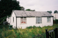
                                                     This cottage used to stand on Seven Mile Bank at West Pinchbeck. I took these photographs in 2008 and there was a demolition notice posted outside the building, I assume that the demolition has now taken place. This isn't one of the sectional bungalows that could be bought in kit form, it would probably be made by a local smith or builder.


The photo below is of a sectional bungalow from the Boulton and Paul catalogue. It was built by James Noble, wheelwright of Gosberton who owned the adjacent house, land and forge (long since demolished). The cottage was built for James' unmarried daughter, Nina Noble who played the organ in Gosberton Church. The cottage was demolished in 2009 and replaced with a brick house.

Friday 3 September 2010

Humberstone Fitties

The Humberston Fitties Chalet Park is the last remaining (and now protected plotland) on the Lincolnshire Coast, it is an area just outside Cleethorpes that during the early twentieth century was easily accessible by train and motor car. ‘Fitties’ is a Lincolnshire term for a salt marsh and the area of marsh at Humberston was enclosed by the construction of sea bank so that it might be used as agricultural land (common practise on this stretch of coast). This provided a sheltered area immediately behind the sand dunes which by the later nineteenth century was being used as a site for tents and other shelters by holiday makers (Dowling, 2001). The land originally belonged to the estate of the Marquess of Lincolnshire who sold it in 1920 to the Humberston Fitties Company Ltd (sand and gravel extractors) who began the process of selling off plots, eventually coming under the authority of Grimsby Rural District Council. There was, inevitably, an interruption to such activity during the First World War when the coast was inaccessible to the general public but when normality returned in 1919 farmers saw the potential to increase their dwindling incomes by renting or selling plots of land to individuals who then built chalets, huts or shacks on the sites and thus the ‘plotland’ developed (Dowling, 2001; Hardy and Ward, 1984). This is precisely the way that the Humberston Fitties camp initially developed and it is indicative of how similar developments arose elsewhere on the east coast. Unlike many of the other plotlands of this period there is little evidence to suggest that the Lincolnshire plotlands supported a permanent community, forced to live there because of the lack of affordable working class housing post First World War. In his history of the Humberston Fitties camp, Alan Dowling (2001) points out that it is difficult to find the right terminology for the structures that started to spring up at Humberston; ‘chalets’, ‘bungalows’, ‘shacks’ etc all describe such makeshift structures; the fact that some might be constructed out of old omnibus bodies or railway carriages and others might be purpose made sectional wooden bungalows from companies such as Boulton and Paul only strengthened the sense of aesthetic outrage on the part of men like Scorer and Steers. Most makeshift landscapes in Lincolnshire seemed to consist of a combination of both of these types and clearly indicates that those who occupied such plotlands were from a range of income levels and lifestyles. This reflects the kind of divisions that Holtby identifies in her description of the shacks in South Riding, the Holly’s in their converted railway carriages, the Mitchells in their corrugated tin hut. It also indicates that there were some wealthier individuals who deliberately chose to enjoy a holiday in a makeshift environment rather than the more usual seaside accommodation of guest house or hotel, perceiving the lifestyle to be more authentic, more natural and linking to the popularity of romanticised ideals of the ‘gipsy’ lifestyle, a more bohemian experience. This can be ascertained from Dowling’s investigations into the early owner of properties on the Fitties, they included bankers, estate agents, florists, butchers, fishermen, hairdressers and general practitioners. None of the original occupants appear to have been forced there by poverty; rather they represent those wanting to enjoy their leisure time in a coastal environment for the reasons outlined in earlier chapters. Dowling cites an example of this as remembered by one early Fitties resident: 

Servants were brought along if anyone had them. My mother allowed hers to do without her cap when camping. I was never allowed to present anyone with a cup of tea unless it was one a small tray... when silver teapots appeared my father thought it was the beginning of the end...

(Dowling, p.34, 2001)

 
Dowling’s research also reveals that a majority of those visiting the Fitties during the inter war period were relatively local, from Grimsby and Cleethorpes with a few more distant visitors from the industrial midlands. Between 1920 and 1929 the camp expanded from one wooden bungalow to 153 buildings causing Grimsby RDC to impose a planning restriction on the site, by 1939 there were 174 including 54 actually in the sand hills themselves. Such developments lead to a long and complex process of negotiation with the RDC and the eventual adoption of the site by them, it is because of this local authority intervention and the tenacious efforts of several Fitties residents that it is not only still in existence but in 1995 became a conservation area.


Dowling A (2001) Humberston Fitties: The Story of a Lincolnshire Plotland, Cleethorpes: Dowling

www.globrix.com/property/buy/dn36/Humberston-fitties.com 13/09/09

Hardy D and Ward C (1984) Arcadia for All: The Legacy of a Makeshift Landscape, Five Leaves: Nottingham


Holtby W (1936) South Riding: An English Landscape, London: Collins


Mills D (ed.) (1989) Twentieth Century Lincolnshire, Lincoln: Yard


Robinson D (1981) The Book of the Lincolnshire Seaside, Buckingham: Baron


Wednesday 1 September 2010

Some comments on Cleethorpes and Skegness...

Drunkenness stalked the street... the tremendous worship of Bacchus at Cleethorpes on Good Friday proclaimed the nearest approach to an earthly pandemonium that I have ever been able to discover...
The Grimsby Observer, August 7th 1878


         Skegness:
...it deserved its ragged-sounding knickname. It was a low, loud, faded seaside resort. It was utterly joyless. Its vulgarity was uninteresting. It was painfully ugly. It made the English seem dangerous. And at last, it made me want to leave – to take long strides down its broad sands and walk all the way to Friskney Flats. But there was no walking here – too muddy, too many of the canals and ditches they called ‘drains’ here, and no path.
 Paul Theroux  (1984)    The  Kingdom by the Sea    p.341

Tuesday 31 August 2010